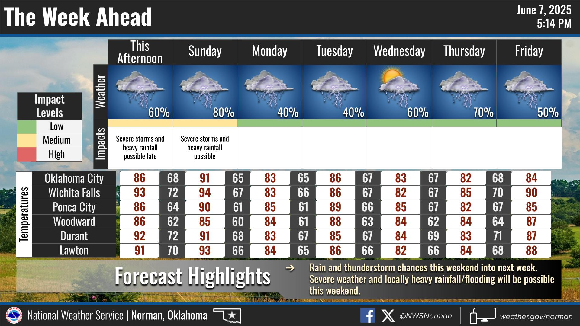


This Afternoon
A 50 percent chance of showers and thunderstorms. Mostly cloudy, with a high near 86. East northeast wind around 7 mph becoming south. New rainfall amounts between a half and three quarters of an inch possible.
Tonight
Showers and possibly a thunderstorm, mainly before 10pm, then a chance of showers and thunderstorms after 10pm. Some of the storms could produce heavy rainfall. Low around 68. Northeast wind 5 to 7 mph becoming light and variable after midnight. Chance of precipitation is 80%. New rainfall amounts between a quarter and half of an inch possible.
Sunday
A 50 percent chance of showers and thunderstorms, mainly before 1pm. Mostly cloudy, with a high near 83. East wind 5 to 7 mph. New rainfall amounts of less than a tenth of an inch, except higher amounts possible in thunderstorms.
Sunday Night
Mostly cloudy, with a low around 68. East southeast wind 3 to 7 mph.
Monday
A 20 percent chance of showers and thunderstorms. Partly sunny, with a high near 87. South wind 5 to 9 mph.
Monday Night
A 20 percent chance of showers and thunderstorms after 1am. Partly cloudy, with a low around 70.
Tuesday
A 30 percent chance of showers and thunderstorms, mainly after 1pm. Mostly sunny, with a high near 92.
Tuesday Night
A 20 percent chance of showers and thunderstorms after 1am. Partly cloudy, with a low around 72.
Wednesday
A 30 percent chance of showers and thunderstorms, mainly after 1pm. Mostly sunny, with a high near 92.
Wednesday Night
A 40 percent chance of showers and thunderstorms. Partly cloudy, with a low around 71.
Thursday
A 20 percent chance of showers and thunderstorms. Mostly sunny, with a high near 91.
Thursday Night
A 30 percent chance of showers and thunderstorms. Partly cloudy, with a low around 70.
Friday
A 20 percent chance of showers and thunderstorms. Mostly sunny, with a high near 91.
Flood Watch-National Weather Service Norman OK
1203 PM CDT Sat Jul 12 2025
OKZ008-009-012>048-050>052-TXZ086-089-090-131000-
/O.CON.KOUN.FA.A.0012.000000T0000Z-250714T0000Z/
/00000.0.ER.000000T0000Z.000000T0000Z.000000T0000Z.OO/
Kay-Ellis-Garfield-Noble-Roger Mills-Dewey-Custer-Blaine-
Kingfisher-Logan-Payne-Beckham-Washita-Caddo-Canadian-Oklahoma-
Lincoln-Grady-McClain-Cleveland-Pottawatomie-Seminole-Hughes-
Harmon-Greer-Kiowa-Jackson-Tillman-Comanche-Stephens-Garvin-
Murray-Pontotoc-Coal-Cotton-Jefferson-Carter-Johnston-Atoka-Love-
Marshall-Bryan-Wichita-Archer-Clay-
Including the cities of Hennessey, Durant, Concho, Stroud,
Okarche, Blanchard, Gage, Leedey, Altus, Thackerville, Hinton,
Pauls Valley, Seminole, Clinton, Shattuck, Arnett, Ringling,
Guthrie, Holliday, Seiling, Newcastle, Moore, Granite, Watonga,
Ponca City, Madill, Wellston, Mustang, El Reno, Perry,
Stillwater, Tuttle, Kingston, Davis, Coalgate, Sheppard AFB,
Wynnewood, Lindsay, Marietta, Archer City, Hammon, Waurika,
Ardmore, Fargo, Walters, Purcell, Ada, Frederick, Mangum, Sayre,
Cordell, Geary, Blackwell, Prague, Sentinel, Kingfisher, Wichita
Falls, Taloga, Ryan, Lakeside City, Shawnee, Lawton, Chandler,
Weatherford, Chickasha, Duncan, Cheyenne, Hobart, Davenport,
Oklahoma City, Yukon, Burns Flat, Henrietta, Tishomingo, Wetumka,
Hollis, Anadarko, Temple, Scotland, Holdenville, Enid, Atoka,
Okeene, Snyder, Sulphur, Wewoka, Elk City, Meeker, Vici, and
Norman
1203 PM CDT Sat Jul 12 2025
...FLOOD WATCH REMAINS IN EFFECT THROUGH SUNDAY EVENING...
* WHAT...Flooding caused by excessive rainfall continues to be
  possible.
* WHERE...Portions of Oklahoma, including the following counties,
  Atoka, Beckham, Blaine, Bryan, Caddo, Canadian, Carter, Cleveland,
  Coal, Comanche, Cotton, Custer, Dewey, Ellis, Garfield, Garvin,
  Grady, Greer, Harmon, Hughes, Jackson, Jefferson, Johnston, Kay,
  Kingfisher, Kiowa, Lincoln, Logan, Love, Marshall, McClain,
  Murray, Noble, Oklahoma, Payne, Pontotoc, Pottawatomie, Roger
  Mills, Seminole, Stephens, Tillman and Washita and northern Texas,
  including the following counties, Archer, Clay and Wichita.
* WHEN...Through Sunday evening.
* IMPACTS...Excessive runoff may result in flooding of rivers,
  creeks, streams, and other low-lying and flood-prone locations.
  Flooding may occur in poor drainage and urban areas. Low-water
  crossings may be flooded.
* ADDITIONAL DETAILS...
  - Multiple rounds of heavy rain are expected this weekend,
    particularly today and tonight. Widespread totals of 1-2
    inches of rain are expected, with some locations expected to
    receive up to 4 inches of rain.
  - http://www.weather.gov/safety/flood
PRECAUTIONARY/PREPAREDNESS ACTIONS...You should monitor later forecasts and be alert for possible Flood
Warnings. Those living in areas prone to flooding should be prepared
to take action should flooding develop.