Area Forecast
Ponca City Now-NWS and Oklahoma Mesonet - July 12, 2023 4:51 pm
4:50 pm-97 degrees with heat index of 109 in Ponca City.
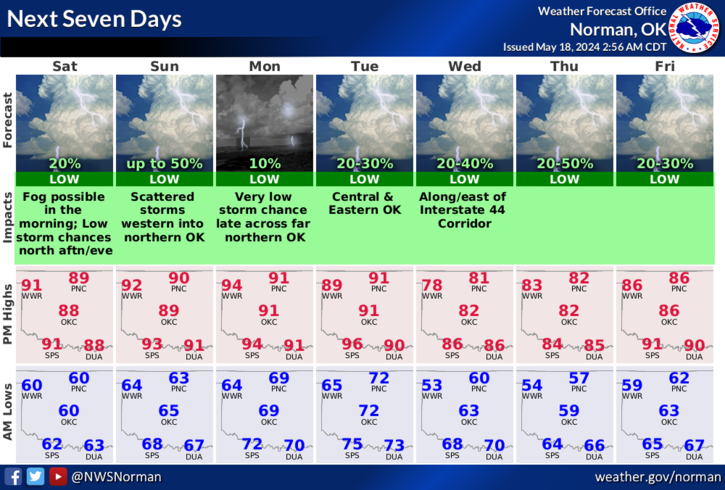
This Afternoon
Sunny and hot, with a high near 98. Heat index values as high as 114. South wind around 13 mph.
Harper-Woods-Alfalfa-Grant-Kay-Ellis-
Woodward-Major-Garfield-
Noble-Roger Mills-Dewey-Custer-
Blaine-Kingfisher-Logan-Payne-
Beckham-Washita-Caddo-Canadian-
Oklahoma-Lincoln-Grady-McClain-
Cleveland-Pottawatomie-Seminole-
Hughes-Harmon-Greer-Kiowa-Jackson-
Tillman-Comanche-Stephens-Garvin-
Murray-Pontotoc-Coal-Cotton-
Jefferson-Carter-Johnston-Atoka-
Love-Marshall-Bryan-Hardeman-
Foard-Wilbarger-Wichita-
Knox-Baylor-Archer-Clay-
256 PM CDT Wed Jul 12 2023
This hazardous weather outlook is for portions of northern...
western...central...and southern Oklahoma...and western north
Texas.
DAY ONE...Through Tonight...
.Excessive Heat...
Dangerous triple digit heat indices up to 110 to 120 degrees will
be possible this afternoon into the early evening. An Excessive
Heat Warning will be in effect today from noon through 9 PM across
our entire Oklahoma and western north Texas counties.
Tonight
A 30 percent chance of showers and thunderstorms, mainly before 1am. Partly cloudy, with a low around 74. South wind 8 to 11 mph becoming east after midnight.
Thursday – Mostly sunny, with a high near 94. Heat index values as high as 106. East wind around 10 mph.**EXCESSIVE HEAT WARNING REMAINS IN EFFECT UNTIL 9 PM CDT THIS EVENING. HEAT ADVISORY IN EFFECT FROM NOON TO 9 PM CDT THURSDAY… * WHAT…For the Excessive Heat Warning, dangerously hot conditions with heat index values up to 116. For the Heat Advisory, heat index values up to 110 expected. * WHERE…Portions of central, northern, northwest, southwest and western Oklahoma. * WHEN…For the Excessive Heat Warning, until 9 PM CDT this evening. For the Heat Advisory, from noon to 9 PM CDT Thursday. * IMPACTS…Extreme heat and humidity will significantly increase the potential for heat related illnesses, particularly for those working or participating in outdoor activities. PRECAUTIONARY/PREPAREDNESS ACTIONS… Drink plenty of fluids, stay in an air-conditioned room, stay out of the sun, and check up on relatives and neighbors. Young children and pets should never be left unattended in vehicles under any circumstances. Take extra precautions if you work or spend time outside. When possible reschedule strenuous activities to early morning or evening. Know the signs and symptoms of heat exhaustion and heat stroke. Wear lightweight and loose fitting clothing when possible. To reduce risk during outdoor work, the Occupational Safety and Health Administration recommends scheduling frequent rest breaks in shaded or air conditioned environments. Anyone overcome by heat should be moved to a cool and shaded location. Heat stroke is an emergency! Call 9 1 1.
Thursday Night
A 50 percent chance of showers and thunderstorms. Mostly cloudy, with a low around 73. East wind 8 to 13 mph becoming south after midnight. Winds could gust as high as 20 mph.
Thunderstorms will be possible this evening across portions of northern Oklahoma. A few of these storms could become severe with up to golf ball size hail and damaging wind gusts as the potential severe hazards. Additional storms may be possible after midnight across east central portions of Oklahoma, but these are not expected to become severe. .
Friday
A 40 percent chance of showers and thunderstorms. Partly sunny, with a high near 93. South southwest wind 8 to 10 mph.
Friday Night
Showers and thunderstorms likely, mainly before 1am. Mostly cloudy, with a low around 69. Chance of precipitation is 60%.
Saturday
A 20 percent chance of showers and thunderstorms after 1pm. Mostly sunny, with a high near 89.
Saturday Night
A 30 percent chance of showers and thunderstorms. Mostly cloudy, with a low around 68.
Sunday
Sunny, with a high near 89.
Sunday Night
A 20 percent chance of showers and thunderstorms after 1am. Mostly clear, with a low around 68.
Monday
A 20 percent chance of showers and thunderstorms. Mostly sunny, with a high near 92.
Monday Night
A 20 percent chance of showers and thunderstorms. Partly cloudy, with a low around 71.
Tuesday
Sunny and hot, with a high near 97.
Tuesday Night
Mostly clear, with a low around 76.
Wednesday
Mostly sunny and hot, with a high near 98.
DAYS TWO THROUGH SEVEN…Thursday through Tuesday... .Excessive Heat… Dangerous hot conditions will return on Thursday afternoon across much of our area as well as on Friday afternoon. Dangerous heat may be returning again on Monday and Tuesday across western north Texas and portions of southern Oklahoma. .Thunderstorms… Thunderstorms will be possible late Thursday afternoon into the overnight hours across northern, western, and central Oklahoma and again on Friday evening and overnight generally along and north of I-40. Large hail and damaging winds gusts will be the potential severe risks for both days, as well as heavy rainfall resulting in flooding in some areas. Thunderstorms will also be possible this weekend on Saturday and Sunday.